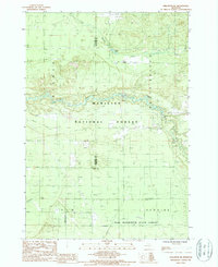
1987 Map of Wellston NE
USGS Topo · Published 1988About this map
The Manistee National Forest and Pere Marquette State Forest converge in this 1980s landscape, where the Pine River and its South Branch wind through dense woodlands. The terrain is marked by the legacy of early Michigan industry, clearly evidenced by the Old Railroad Grade cutting across the central forest and several Gravel Pits scattered near the township boundaries. Local movement and resource extraction shaped this area, leaving behind artifacts of the timber and transport era.
Find a feature on this map
23 named features on this map. Tap any name to fly to it.
Don’t see what you’re looking for? This feature index may not catch every label — zoom into the map to look around manually.
Map Details
Editions of this 1987 Wellston NE Map
This is the sole edition of this map. No revisions or reprints were ever made.
Other maps of this area

1933 · Peacock SE
USGS Topo · 1:31,680

1933 · Peacock SW
USGS Topo · 1:31,680

1933 · Peacock NE
USGS Topo · 1:31,680

1933 · Luther SW
USGS Topo · 1:31,680

1933 · Luther NW
USGS Topo · 1:31,680

1933 · Peacock NW
USGS Topo · 1:31,680

1954 · Traverse City
USGS Topo · 1:250,000

1956 · Mesick
USGS Topo · 1:62,500

1957 · Copemish
USGS Topo · 1:62,500

1957 · Luther
USGS Topo · 1:62,500
Featured Places
- Eden Township, MI
- Newkirk Township, MI
- Norman Township, MI
- South Branch Township, MI
- Garletts Corner, MI