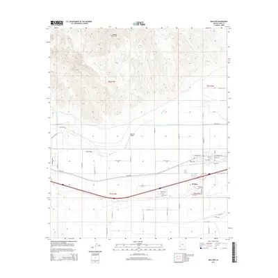
2014 Map of Wellton
USGS Topo · Published 2014About this map
The Gila River corridor defines this arid landscape, where the fertile expanses of Dome Valley and Mohawk Valley meet the rising slopes of the Muggins Mountains. This 2014 survey captures the agricultural and transit infrastructure of Wellton, a community built around its proximity to the river and critical overland routes. The map documents an extensive network of local roads and levees, including N Gila Levee Rd and S Gila Levee Rd, which protect the low-lying valley floors from seasonal fluctuations in the riverbed. Historic transit corridors are prominently visible, notably the path of Old US-80 and the southern approach of the Camino Del Diablo. Significant drainage features such as Morgan Wash and Coyote Wash St emphasize the hydrologic character of the region, illustrating how water management has shaped the modern settlement patterns in this part of Yuma County.
Find a feature on this map
47 named features on this map. Tap any name to fly to it.
Don’t see what you’re looking for? This feature index may not catch every label — zoom into the map to look around manually.
Map Details
Editions of this 2014 Wellton Map
This is the sole edition of this map. No revisions or reprints were ever made.
Other maps of this area

1926 · Fortuna
USGS Topo · 1:62,500

1926 · Wellton
USGS Topo · 1:62,500

1929 · Fortuna
USGS Topo · 1:62,500

1929 · Laguna
USGS Topo · 1:62,500

1929 · Wellton
USGS Topo · 1:62,500

1942 · Yuma
USGS Topo · 1:250,000

1943 · Laguna
USGS Topo · 1:62,500

1954 · El Centro
USGS Topo · 1:250,000

1955 · El Centro
USGS Topo · 1:250,000
1955 · Dome
USGS Topo · 1:24,000