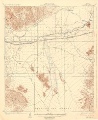
1929 Map of Wellton
USGS Topo · Published 1929About this map
The Gila River corridor dominates this desert landscape, where early 20th-century irrigation and transport infrastructure define the local geography. Following the river's northern bend, the Southern Pacific railroad provides the primary axis for settlements like Wellton, Adonde, and Tacna. The map reveals the critical importance of water management in the Gila Valley, detailing the paths of the Antelope Canal and Bend Canal, alongside the unique presence of Radium Hot Springs to the north. South of the tracks, the terrain transitions into the arid expanse of the Lechuguilla Desert, interrupted only by the Wellton Hills and the seasonal path of Coyote Wash. The detailed survey of the Muggins Mountains and Gila Mountains illustrates the stark relief surrounding these rail-side agricultural outposts.
Find a feature on this map
22 named features on this map. Tap any name to fly to it.
Don’t see what you’re looking for? This feature index may not catch every label — zoom into the map to look around manually.
Map Details
Editions of this 1929 Wellton Map
3 editions found
Other maps of this area

1926 · Fortuna
USGS Topo · 1:62,500

1926 · Wellton
USGS Topo · 1:62,500

1926 · Mohawk
USGS Topo · 1:62,500

1928 · Mohawk
USGS Topo · 1:62,500

1928 · Norton
USGS Topo · 1:62,500

1929 · Fortuna
USGS Topo · 1:62,500

1929 · Laguna
USGS Topo · 1:62,500

1929 · Wellton
USGS Topo · 1:62,500

1929 · Norton
USGS Topo · 1:62,500

1942 · Yuma
USGS Topo · 1:250,000