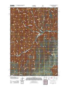
2011 Map of Wenaha Forks
USGS Topo · Published 2011About this map
Wenaha Forks marks the confluence where the North Fork Wenaha River and South Fork Wenaha River join to form the main stem of the Wenaha River. This high-country landscape in Wallowa County is defined by a series of prominent divides, including Beaver Ridge, Sawtooth Ridge, and Dexter Ridge, which separate the various tributaries feeding into the river system. The presence of Peerless Spring and numerous named drainages like Slick Ear Creek and Jaussaud Creek illustrate the complex watershed of this mountain terrain. Evidence of high-altitude navigation and land use is visible in the network of Forest Service roads and trails that traverse areas like Elk Flat and the slopes near Round Butte. This 2011 survey records the topographical layout of these ridges and canyons, providing a baseline for researchers interested in the geomorphology and land-management history of the Oregon-Washington border region.
Find a feature on this map
30 named features on this map. Tap any name to fly to it.
Don’t see what you’re looking for? This feature index may not catch every label — zoom into the map to look around manually.
Map Details
Editions of this 2011 Wenaha Forks Map
This is the sole edition of this map. No revisions or reprints were ever made.
Other maps of this area

1937 · Pomeroy
USGS Topo · 1:96,000

1942 · Pomeroy
USGS Topo · 1:125,000

1955 · Pullman
USGS Topo · 1:250,000

1955 · Grangeville
USGS Topo · 1:250,000

1958 · Pullman
USGS Topo · 1:250,000

1959 · Grangeville
USGS Topo · 1:250,000

1967 · Fry Meadow
USGS Topo · 1:24,000

1967 · Elbow Creek
USGS Topo · 1:24,000
1967 · Bone Spring
USGS Topo · 1:24,000

1967 · Oregon Butte
USGS Topo · 1:24,000