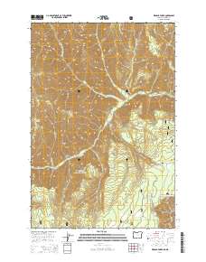
2014 Map of Wenaha Forks
USGS Topo · Published 2014About this map
Wenaha Forks serves as the central confluence of this remote Wallowa County landscape, where the North Fork Wenaha River and South Fork Wenaha River meet within the boundaries of the Umatilla National Forest. The topography is defined by a series of prominent high-elevation features including Sawtooth Ridge, Dexter Ridge, and Trapper Ridge, which dictate the drainage patterns of numerous creeks like Slick Ear Cr and Jaussaud Cr. This 2014 survey documents the modern road network essential for forest management, such as Nat For Dev RD 270 and Timothy Spring Rd. These routes provide access to isolated points like Elk Flat and Trapper Spring, reflecting a wilderness area primarily utilized for conservation and seasonal transit rather than permanent settlement.
Find a feature on this map
29 named features on this map. Tap any name to fly to it.
Don’t see what you’re looking for? This feature index may not catch every label — zoom into the map to look around manually.
Map Details
Editions of this 2014 Wenaha Forks Map
This is the sole edition of this map. No revisions or reprints were ever made.
Other maps of this area

1937 · Pomeroy
USGS Topo · 1:96,000

1942 · Pomeroy
USGS Topo · 1:125,000

1955 · Pullman
USGS Topo · 1:250,000

1955 · Grangeville
USGS Topo · 1:250,000

1958 · Pullman
USGS Topo · 1:250,000

1959 · Grangeville
USGS Topo · 1:250,000

1967 · Fry Meadow
USGS Topo · 1:24,000

1967 · Elbow Creek
USGS Topo · 1:24,000
1967 · Bone Spring
USGS Topo · 1:24,000

1967 · Oregon Butte
USGS Topo · 1:24,000