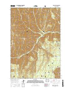
2017 Map of Wenaha Forks
USGS Topo · Published 2017About this map
Umatilla National Forest encompasses the deep drainages and sharp divides of this corner of the Blue Mountains, where the North and South Forks converge at Wenaha Forks. The drainage pattern is exceptionally defined, with steep ridges like Sawtooth Ridge, Dexter Ridge, and Beaver Ridge separating the various creek systems. This 2017 survey illustrates a landscape primarily accessible by an extensive network of foot and pack trails rather than roads, reflecting the managed wilderness character of the Wallowa County and Columbia County borderlands.
Find a feature on this map
39 named features on this map. Tap any name to fly to it.
Don’t see what you’re looking for? This feature index may not catch every label — zoom into the map to look around manually.
Map Details
Editions of this 2017 Wenaha Forks Map
This is the sole edition of this map. No revisions or reprints were ever made.
Other maps of this area

1937 · Pomeroy
USGS Topo · 1:96,000

1942 · Pomeroy
USGS Topo · 1:125,000

1955 · Pullman
USGS Topo · 1:250,000

1955 · Grangeville
USGS Topo · 1:250,000

1958 · Pullman
USGS Topo · 1:250,000

1959 · Grangeville
USGS Topo · 1:250,000

1967 · Fry Meadow
USGS Topo · 1:24,000

1967 · Elbow Creek
USGS Topo · 1:24,000
1967 · Bone Spring
USGS Topo · 1:24,000

1967 · Oregon Butte
USGS Topo · 1:24,000