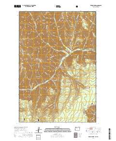
2020 Map of Wenaha Forks
USGS Topo · Published 2020About this map
The Wenaha Wild and Scenic River defines this landscape within the Umatilla National Forest, where the N Fork Wenaha River and S Fork Wenaha River converge. This area of the Blue Mountains is characterized by a series of steep, parallel ridges including Beaver Ridge, Sawtooth Ridge, and Dexter Ridge. The map details an extensive network of primitive paths such as the Wenaha River Trail and Slick Ear Trail, which provide the primary means of navigating the deep drainages of Beaver Cr and Rock Cr. High-elevation landmarks like Round Butte and Elk Flat serve as key orientation points for backcountry travelers. Near the southern boundary, Jaussaud Cr and Jarboe Cr drain toward the river system, while water sources like Trapper Spring and Peerless Spring indicate the essential locations for early wilderness survival and modern recreation.
Find a feature on this map
34 named features on this map. Tap any name to fly to it.
Don’t see what you’re looking for? This feature index may not catch every label — zoom into the map to look around manually.
Map Details
Editions of this 2020 Wenaha Forks Map
This is the sole edition of this map. No revisions or reprints were ever made.
Other maps of this area

1937 · Pomeroy
USGS Topo · 1:96,000

1942 · Pomeroy
USGS Topo · 1:125,000

1955 · Pullman
USGS Topo · 1:250,000

1955 · Grangeville
USGS Topo · 1:250,000

1958 · Pullman
USGS Topo · 1:250,000

1959 · Grangeville
USGS Topo · 1:250,000

1967 · Fry Meadow
USGS Topo · 1:24,000

1967 · Elbow Creek
USGS Topo · 1:24,000
1967 · Bone Spring
USGS Topo · 1:24,000

1967 · Oregon Butte
USGS Topo · 1:24,000