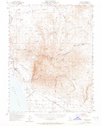
1954 Map of Wendel
USGS Topo · Published 1965About this map
Honey Lake dominates the southwestern corner of this high-desert landscape in Lassen County, where the alkaline waters meet the rising slopes of the Skedaddle Mountains. The transition from the lakebed to the peaks is marked by geothermal activity, notably at Amedee Hot Springs and Hot Springs Peak, signaling the region's active geology. Transportation and infrastructure follow the contours of the basin, with the Southern Pacific line skirting the lakeshore near the town of Wendel and the military installations of the Sierra Ordnance Depot.
Find a feature on this map
60 named features on this map. Tap any name to fly to it.
Don’t see what you’re looking for? This feature index may not catch every label — zoom into the map to look around manually.
Map Details
Editions of this 1954 Wendel Map
2 editions found
Other maps of this area

1886 · Honey Lake
USGS Topo · 1:250,000

1886 · Granite Range
USGS Topo · 1:250,000

1891 · Honey Lake
USGS Topo · 1:250,000

1893 · Honey Lake
USGS Topo · 1:250,000

1894 · Granite Range
USGS Topo · 1:250,000

1950 · Milford
USGS Topo · 1:62,500

1954 · Wendel
USGS Topo · 1:62,500

1954 · Litchfield
USGS Topo · 1:62,500

1954 · Karlo
USGS Topo · 1:62,500

1954 · Doyle
USGS Topo · 1:62,500