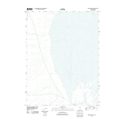
2011 Map of Wendover SE
USGS Topo · Published 2011About this map
Blue Lake and Salt Springs anchor the southeastern corner of this arid landscape, revealing a rare cluster of perennial water features in the Great Salt Lake Desert. The terrain is largely defined by the expansive salt flats and playa characteristic of the region, where drainage patterns like Felt Wash cut through the western edge of the quadrangle. This 2011 survey illustrates the stark hydrologic boundary where the desert floor meets the localized wetlands near the state border, documenting the distribution of these spring-fed pools as they appeared in the early 21st century. The map provides a detailed view of the natural hydrology and the primitive road network that navigates this remote environment, serving as a point of reference for understanding the seasonal and permanent water sources in this section of Tooele County.
Find a feature on this map
3 named features on this map. Tap any name to fly to it.
Don’t see what you’re looking for? This feature index may not catch every label — zoom into the map to look around manually.
Map Details
Editions of this 2011 Wendover SE Map
This is the sole edition of this map. No revisions or reprints were ever made.
Other maps of this area

1953 · Tooele
USGS Topo · 1:250,000

1955 · Tooele
USGS Topo · 1:250,000

1955 · Elko
USGS Topo · 1:250,000

1958 · Elko
USGS Topo · 1:250,000

1962 · Elko
USGS Topo · 1:250,000

1965 · Elko
USGS Topo · 1:250,000

1972 · Ferguson Flat
USGS Topo · 1:24,000

1972 · Ferguson Mtn.
USGS Topo · 1:24,000

1972 · Ola
USGS Topo · 1:24,000
1972 · Spring Gulch
USGS Topo · 1:24,000