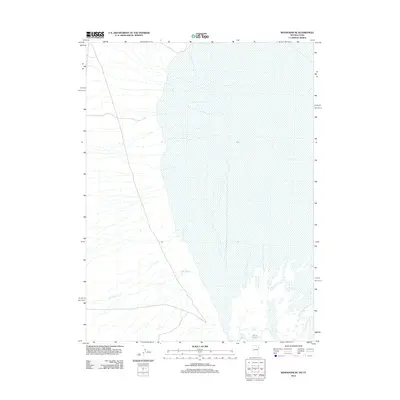
2012 Map of Wendover SE
USGS Topo · Published 2012About this map
Blue Lake sits at the base of the salt flats in this 2012 survey of the Tooele County borderlands. The terrain is defined by the sharp transition between the western desert floor and the marshy edges of the great basins. Braided drainage patterns such as Felt Wash cut through the arid landscape, channeling seasonal runoff toward the low-lying wetlands. The map illustrates a largely uninhabited expanse where modern roads skirt the edge of the vast salt-encrusted plains. This specific environment highlights the hydrological balance of the region, where isolated water bodies like Blue Lake provide critical reference points in an otherwise feature-sparse desert geography.
Find a feature on this map
2 named features on this map. Tap any name to fly to it.
Don’t see what you’re looking for? This feature index may not catch every label — zoom into the map to look around manually.
Map Details
Editions of this 2012 Wendover SE Map
This is the sole edition of this map. No revisions or reprints were ever made.
Other maps of this area

1953 · Tooele
USGS Topo · 1:250,000

1955 · Tooele
USGS Topo · 1:250,000

1955 · Elko
USGS Topo · 1:250,000

1958 · Elko
USGS Topo · 1:250,000

1962 · Elko
USGS Topo · 1:250,000

1965 · Elko
USGS Topo · 1:250,000

1972 · Ferguson Flat
USGS Topo · 1:24,000

1972 · Ferguson Mtn.
USGS Topo · 1:24,000

1972 · Ola
USGS Topo · 1:24,000
1972 · Spring Gulch
USGS Topo · 1:24,000