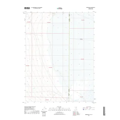
2018 Map of Wendover SE
USGS Topo · Published 2018About this map
Great Salt Lake Desert dominates the eastern landscape of this 2018 survey, where the arid basin floor of Tooele Co meets the Nevada state line. This borderland region is characterized by the stark transition from the alluvial fans of the Pilot Range to the expansive salt flats of the ancient Lake Bonneville bed. To the south, the presence of Blue Lake provides a rare perennial water feature in an otherwise parched environment, while Felt Wash drains the western slopes toward the desert floor. The map meticulously documents the Public Land Survey System grid, showing the intersection of several townships including t31n r70e and t4s r19w, which are essential for identifying specific historical land parcels and grazing allotments along the interstate boundary.
Find a feature on this map
13 named features on this map. Tap any name to fly to it.
Don’t see what you’re looking for? This feature index may not catch every label — zoom into the map to look around manually.
Map Details
Editions of this 2018 Wendover SE Map
This is the sole edition of this map. No revisions or reprints were ever made.
Other maps of this area

1953 · Tooele
USGS Topo · 1:250,000

1955 · Tooele
USGS Topo · 1:250,000

1955 · Elko
USGS Topo · 1:250,000

1958 · Elko
USGS Topo · 1:250,000

1962 · Elko
USGS Topo · 1:250,000

1965 · Elko
USGS Topo · 1:250,000

1972 · Ferguson Flat
USGS Topo · 1:24,000

1972 · Ferguson Mtn.
USGS Topo · 1:24,000

1972 · Ola
USGS Topo · 1:24,000
1972 · Spring Gulch
USGS Topo · 1:24,000