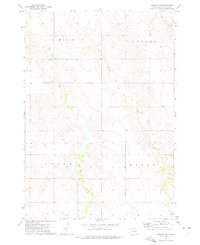
1972 Map of Wendte SW
USGS Topo · Published 1975About this map
White Clay Creek and its East Branch carve a winding path through this portion of Jones County, defining a landscape of high plains and drainage systems. The map reflects a rural South Dakota geography organized by large townships, including Van Metre, Banner, Union, and Kolls. These divisions speak to the early 20th-century settlement patterns of the region, where wide-open spaces were segmented for ranching and agriculture.
Find a feature on this map
8 named features on this map. Tap any name to fly to it.
Don’t see what you’re looking for? This feature index may not catch every label — zoom into the map to look around manually.
Map Details
Editions of this 1972 Wendte SW Map
This is the sole edition of this map. No revisions or reprints were ever made.
Other maps of this area

1951 · Van Metre
USGS Topo · 1:24,000

1951 · Capa SE
USGS Topo · 1:24,000

1953 · Wendte
USGS Topo · 1:24,000

1953 · Wendte NE
USGS Topo · 1:24,000

1954 · Pierre
USGS Topo · 1:250,000

1955 · Martin
USGS Topo · 1:250,000

1958 · Pierre
USGS Topo · 1:250,000

1958 · Martin
USGS Topo · 1:250,000

1972 · Draper
USGS Topo · 1:24,000

1972 · Murdo
USGS Topo · 1:24,000