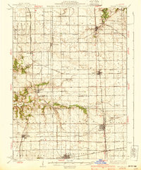
1939 Map of Wenona
USGS Topo · Published 1939About this map
Agricultural life in North Central Illinois is meticulously documented here, where three counties—Putnam, La Salle, and Marshall—converge. The landscape is defined by an intensive network of one-room schoolhouses, including the uniquely named Black College Sch and Brushy College Sch, reflecting the importance of local education in these rural townships. The map records the transition of transportation, noting the Central Illinois (Abandoned) rail line alongside active routes of the New York Central and Illinois Central.
Find a feature on this map
83 named features on this map. Tap any name to fly to it.
Don’t see what you’re looking for? This feature index may not catch every label — zoom into the map to look around manually.
Map Details
Editions of this 1939 Wenona Map
2 editions found

Other maps of this area

1892 · Ottawa
USGS Topo · 1:62,500

1893 · Lacon
USGS Topo · 1:62,500

1893 · Hennepin
USGS Topo · 1:62,500

1893 · Metamora
USGS Topo · 1:62,500

1893 · Lasalle
USGS Topo · 1:62,500

1909 · Hennepin
USGS Topo · 1:62,500

1911 · La Salle
USGS Topo · 1:62,500

1911 · Hennepin
USGS Topo · 1:62,500

1913 · La Salle
USGS Topo · 1:62,500

1915 · Ottawa
USGS Topo · 1:62,500