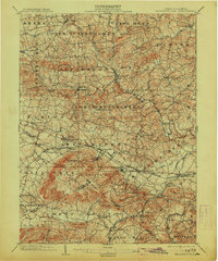
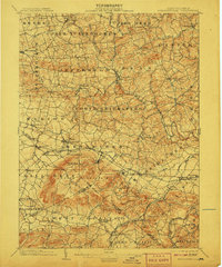
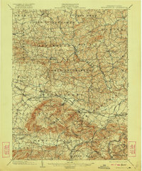
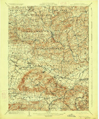
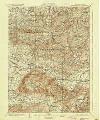
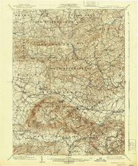
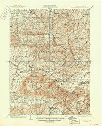
1902 Map of Wernersville
USGS Topo · Published 1913About this map
South Mountain dominates the southern landscape of this turn-of-the-century survey, rising above a network of valleys defined by Tulpehocken Creek and Cacoosing Creek. The region is a dense corridor of early Pennsylvania industry and institutional history, notably featuring the Insane Asylum and Orphans Home near Wernersville. The transport infrastructure of the era is clearly marked, with the Philadelphia and Reading R. R. and its Lebanon Division facilitating trade through settlements like Robesonia and Sinking Spring. Local economic life is further evidenced by several surviving water-power sites, including Hicks Mill and Hiesters Mill. In the southeast, the terrain transitions into the Adamstown Ridge, while the northern portion of the map shows the rural township structures of Jefferson, Penn, and North Heidelberg before modern suburban development altered these traditional agricultural boundaries.
Find a feature on this map
77 named features on this map. Tap any name to fly to it.
Don’t see what you’re looking for? This feature index may not catch every label — zoom into the map to look around manually.
Map Details
Editions of this 1902 Wernersville Map
8 editions found
Other maps of this area

1889 · Pottsville
USGS Topo · 1:62,500

1891 · Pottsville
USGS Topo · 1:62,500

1891 · Lebanon
USGS Topo · 1:62,500

1892 · Pine Grove
USGS Topo · 1:62,500

1893 · Lebanon
USGS Topo · 1:62,500

1894 · Reading
USGS Topo · 1:62,500

1899 · Lebanon
USGS Topo · 1:62,500

1902 · Wernersville
USGS Topo · 1:62,500

1902 · Lancaster
USGS Topo · 1:62,500

1904 · Lancaster
USGS Topo · 1:62,500