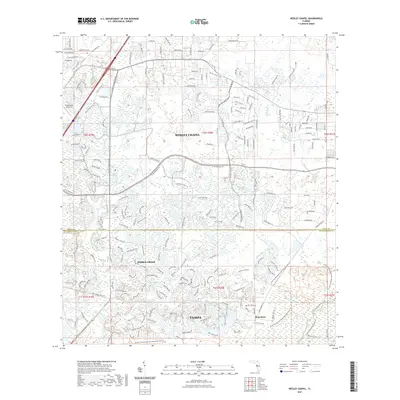
2021 Map of Wesley Chapel
USGS Topo · Published 2021About this map
Wesley Chapel and the northern reaches of Tampa define this landscape as it appeared in the early 21st century. The map illustrates a period of significant suburban expansion across the Pasco and Hillsborough county line, where residential developments like Pebble Creek and Branchton interface with a complex network of waterways. The Hillsborough River and its tributaries, including New River, Trout Creek, and Basset Branch, snake through the terrain, creating a natural structure that persists despite the dense grid of newer roads. Significant transportation corridors like Bruce B Downs Blvd and Co Rd 54 anchor the regional commerce. Notable local landmarks include the Tampa North Aero Park and the educational focus of Wiregrass School Rd, providing a detailed record of the infrastructure supporting this rapidly growing Florida corridor.
Find a feature on this map
204 named features on this map. Tap any name to fly to it.
Don’t see what you’re looking for? This feature index may not catch every label — zoom into the map to look around manually.
Map Details
Editions of this 2021 Wesley Chapel Map
This is the sole edition of this map. No revisions or reprints were ever made.
Other maps of this area

1943 · Thonotosassa
USGS Topo · 1:24,000

1943 · Lutz
USGS Topo · 1:24,000

1944 · Sulphur Springs
USGS Topo · 1:31,680

1944 · Wesley Chapel
USGS Topo · 1:31,680

1944 · Lutz
USGS Topo · 1:31,680

1944 · Thonotosassa
USGS Topo · 1:31,680

1944 · Antioch
USGS Topo · 1:31,680

1945 · Sulphur Springs
USGS Topo · 1:31,680

1947 · Zephyrhills
USGS Topo · 1:24,000
1949 · Sulphur Springs
USGS Topo · 1:25,000
Featured Places
- Tampa, FL
- Pebble Creek, FL
- Club Manor East of Grand Hampton, Tampa
- Trout Creek Commons, Tampa
- Branchton, FL