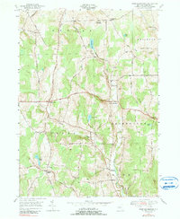
1949 Map of West Bainbridge
USGS Topo · Published 1990About this map
Coventryville and West Bainbridge anchor this rural landscape in the upper Susquehanna River valley region, as recorded during a 1949 field check of earlier 1944 aerial photography. The terrain is defined by a series of north-south drainage networks, including Kelsey Creek and Cheshire Creek, which carve through the high ground of Shapley Hill and Bumps. Small agricultural clusters and family-named crossroads like Blakesley Corner and Puckerville Corners illustrate the mid-century settlement pattern of Chenango County.
Find a feature on this map
49 named features on this map. Tap any name to fly to it.
Don’t see what you’re looking for? This feature index may not catch every label — zoom into the map to look around manually.
Map Details
Editions of this 1949 West Bainbridge Map
2 editions found
Other maps of this area

1902 · Coventry
USGS Topo · 1:62,500

1904 · Oxford
USGS Topo · 1:62,500

1905 · Nineveh
USGS Topo · 1:62,500

1915 · Unadilla
USGS Topo · 1:62,500

1918 · Unadilla
USGS Topo · 1:62,500

1924 · Deposit
USGS Topo · 1:62,500

1926 · Deposit
USGS Topo · 1:62,500

1943 · Sidney
USGS Topo · 1:24,000
1943 · Guilford
USGS Topo · 1:24,000

1944 · Deposit
USGS Topo · 1:62,500