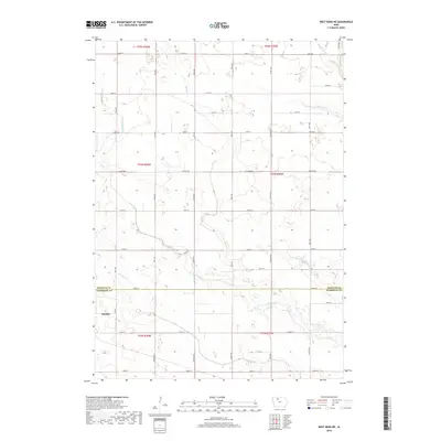
2018 Map of West Bend NE
USGS Topo · Published 2018About this map
Ottosen sits at the southwestern edge of this landscape, marking a concentrated point of settlement where local roads converge near the Kossuth Co and Humboldt Co line. The terrain is defined by a sophisticated water management network where natural waterways like Lotts Creek and Trulner Cr are integrated with man-made improvements, including Drainage Ditch Number 79 and Drainage Ditch Number 8. This hybrid drainage system reflects the region's intensive agricultural character, engineered to reclaim and maintain productive prairie soil. A regular grid of section-line roads, such as Co Hwy B63 and 160th St, segments the land into a patchwork of rural farmsteads typical of the Iowa plains during the early 21st century. The map provides a clear look at the intersection of natural hydrology and the rectilinear human geography of the American Midwest.
Find a feature on this map
25 named features on this map. Tap any name to fly to it.
Don’t see what you’re looking for? This feature index may not catch every label — zoom into the map to look around manually.
Map Details
Editions of this 2018 West Bend NE Map
This is the sole edition of this map. No revisions or reprints were ever made.
Other maps of this area

1954 · Fairmont
USGS Topo · 1:250,000

1954 · Fort Dodge
USGS Topo · 1:250,000

1957 · Fort Dodge
USGS Topo · 1:250,000

1958 · Fort Dodge
USGS Topo · 1:250,000

1958 · Fairmont
USGS Topo · 1:250,000

1972 · Algona
USGS Topo · 1:24,000

1972 · St. Joseph
USGS Topo · 1:24,000

1972 · Livermore
USGS Topo · 1:24,000

1980 · Hobarton
USGS Topo · 1:24,000

1980 · West Bend
USGS Topo · 1:24,000