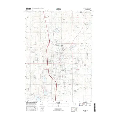
2015 Map of West Bend
USGS Topo · Published 2015About this map
The Milwaukee River carves a path through the heart of this landscape, connecting the industrial and residential core of West Bend with northern settlements like Barton and Young America. By the mid-2010s, the area reflects a complex mix of urban expansion and glacial topography, with numerous water bodies such as Wallace Lake, Smith Lake, and Silver Lake dotting the terrain. The presence of several established burial grounds, including Newark Cem, Old Saint Marys Cem, and Union Cem, offers significant touchpoints for genealogists tracking early families in Washington County. In the south, the West Bend Municipal Airport and residential developments around Paradise Valley Lake show the modern footprint of the city, while the northern reaches near Kewaskum and Orchard Grove maintain a more rural character defined by section lines and winding secondary roads like Ridge Rd and Co Hwy H.
Find a feature on this map
210 named features on this map. Tap any name to fly to it.
Don’t see what you’re looking for? This feature index may not catch every label — zoom into the map to look around manually.
Map Details
Editions of this 2015 West Bend Map
This is the sole edition of this map. No revisions or reprints were ever made.
Other maps of this area

1904 · West Bend
USGS Topo · 1:62,500

1904 · Hartford
USGS Topo · 1:62,500

1955 · Campbellsport
USGS Topo · 1:62,500

1955 · Kewaskum
USGS Topo · 1:62,500

1957 · Madison
USGS Topo · 1:250,000

1959 · West Bend
USGS Topo · 1:62,500

1959 · Hartford
USGS Topo · 1:62,500

1959 · Allenton
USGS Topo · 1:24,000
1959 · Newburg
USGS Topo · 1:24,000
1959 · Jackson
USGS Topo · 1:24,000