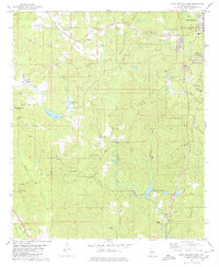
1979 Map of West Blocton West
USGS Topo · Published 1980About this map
Industrial and rural landscapes converge in this survey of central Alabama, where the outskirts of West Blocton meet a terrain defined by coal and timber. The map documents an extensive network of extractive industries, most notably the prominent Strip Mine and smaller operations near Red Eagle and Lucille. Transportation history is clearly etched into the land by an Old RR Gr, marking the paths once used to move raw materials through the valleys of Schultz Creek and McCulley Creek.
Find a feature on this map
65 named features on this map. Tap any name to fly to it.
Don’t see what you’re looking for? This feature index may not catch every label — zoom into the map to look around manually.
Map Details
Editions of this 1979 West Blocton West Map
This is the sole edition of this map. No revisions or reprints were ever made.
Other maps of this area

1899 · Brookwood
USGS Topo · 1:125,000

1931 · Cottondale
USGS Topo · 1:48,000

1934 · Cottondale
USGS Topo · 1:62,500

1934 · Blocton
USGS Topo · 1:48,000

1940 · Blocton
USGS Topo · 1:62,500

1953 · Montgomery
USGS Topo · 1:250,000

1953 · Birmingham
USGS Topo · 1:250,000

1956 · Birmingham
USGS Topo · 1:250,000

1956 · Montgomery
USGS Topo · 1:250,000

1957 · Birmingham
USGS Topo · 1:250,000