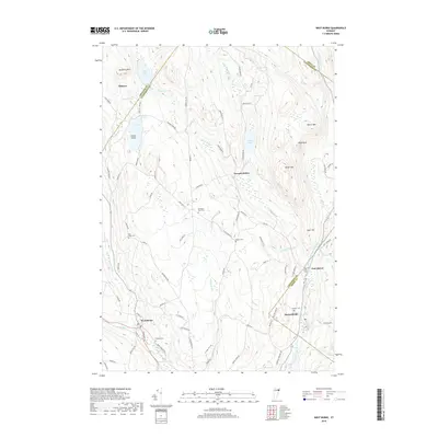
2018 Map of West Burke
USGS Topo · Published 2018About this map
West Burke sits at the southwestern corner of this Vermont landscape, where the Sutton River and the W Br Passumpsic River converge. The topography is defined by the high ridges of McSherry Mtn and Packer Mtn, sheltering a series of glacial ponds including Newark Pond and Center Pond. Small settlements and family farms are scattered throughout the valleys, with Newark Hollow and Hartwellville serving as focal points for rural life. Genealogists will find several burial grounds documented, such as Hillside Cem and Packer Cem, often located near early road networks like Maple Ridge Rd. The eastern portion of the sheet is dominated by the E Br Passumpsic River corridor, which carves through the terrain past East Haven, illustrating the importance of these waterways to the region's historical development and settlement patterns.
Find a feature on this map
87 named features on this map. Tap any name to fly to it.
Don’t see what you’re looking for? This feature index may not catch every label — zoom into the map to look around manually.
Map Details
Editions of this 2018 West Burke Map
This is the sole edition of this map. No revisions or reprints were ever made.
Other maps of this area

1919 · Lake Memphremagog
USGS Topo · 1:62,500

1920 · Derby
USGS Topo · 1:62,500

1923 · Lake Memphremagog
USGS Topo · 1:48,000

1924 · Island Pond
USGS Topo · 1:48,000

1925 · Memphremagog
USGS Topo · 1:62,500

1926 · Island Pond
USGS Topo · 1:62,500

1935 · Lyndonville
USGS Topo · 1:48,000

1939 · Lyndonville
USGS Topo · 1:62,500

1950 · Lake Champlain
USGS Topo · 1:250,000

1950 · Lewiston
USGS Topo · 1:250,000