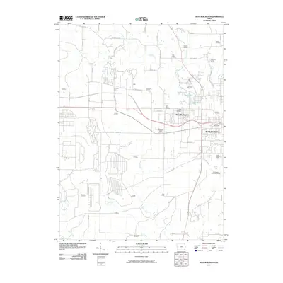
2010 Map of West Burlington
USGS Topo · Published 2010About this map
Burlington and West Burlington serve as the primary hubs in this Des Moines County landscape, where urban infrastructure meets a dense network of historic burial sites. The area is exceptionally notable for its numerous family and denominational cemeteries, such as the Schnupper Farm Cemetery, Mormon Cemetery, and the Jewish Cemetery. These sites are scattered across a terrain defined by the drainage systems of Flint Creek, Brush Creek, and Spring Creek, which eventually lead toward the Skunk River. To the west, the small settlement of Beaverdale remains distinct from the growing suburban sprawl.
Find a feature on this map
75 named features on this map. Tap any name to fly to it.
Don’t see what you’re looking for? This feature index may not catch every label — zoom into the map to look around manually.
Map Details
Editions of this 2010 West Burlington Map
This is the sole edition of this map. No revisions or reprints were ever made.
Other maps of this area

1932 · Lomax
USGS Topo · 1:62,500

1934 · Burlington
USGS Topo · 1:48,000

1936 · Fort Madison
USGS Topo · 1:62,500

1937 · Lomax
USGS Topo · 1:62,500

1940 · Burlington
USGS Topo · 1:62,500

1958 · Burlington
USGS Topo · 1:250,000

1961 · Burlington
USGS Topo · 1:250,000

1963 · Burlington
USGS Topo · 1:250,000
1964 · Burlington
USGS Topo · 1:24,000

1964 · Lomax
USGS Topo · 1:24,000