
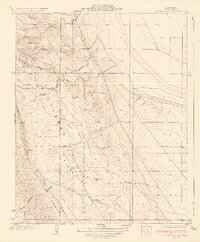
1932 Map of West Camp
USGS Topo · Published 1932About this map
West Camp serves as a primary focal point in this 1932 topographic study, situated along the boundary where Kings County meets Kern County. The landscape is defined by its transition from the flat expanses of the Antelope Plain into more varied terrain near Avenal Gap and Middle Dome. This advance sheet reveals an early 1930s industrial or exploration footprint, characterized by numerous water sources such as Well and the curiously named Mirage. The map is structured around the Sixth Standard Parallel South, providing a precise look at the land partitions and surveying lines used during this era of California's development. Local history researchers can trace the relationship between these early camps and the surrounding physical landmarks like Lost Hills and Lone Tree Well.
Find a feature on this map
10 named features on this map. Tap any name to fly to it.
Don’t see what you’re looking for? This feature index may not catch every label — zoom into the map to look around manually.
Map Details
Editions of this 1932 West Camp Map
This is the sole edition of this map. No revisions or reprints were ever made.
Other maps of this area

1914 · Lost Hills
USGS Topo · 1:125,000

1930 · Avenal Gap
USGS Topo · 1:31,680

1930 · Middle Dome
USGS Topo · 1:31,680

1931 · Harvester
USGS Topo · 1:31,680

1932 · Dudley Ridge
USGS Topo · 1:31,680

1932 · Antelope Plain
USGS Topo · 1:31,680

1932 · Reynolds Ranch
USGS Topo · 1:31,680

1932 · Lone Tree Well
USGS Topo · 1:31,680

1933 · Avenal Gap
USGS Topo · 1:31,680
1934 · Los Viejos Hills
USGS Topo · 1:31,680