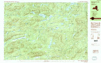
1990 Map of West Canada Lakes
USGS Topo · Published 1990About this map
Adirondack Park lands within the towns of Arietta and Morehouse define this interior portion of Hamilton County. The landscape is dominated by a dense network of high-elevation water bodies, including West Lake, South Lake, and the sprawling Cedar Lakes at the northern edge. Significant peaks like Pillsbury Mtn and Spruce Lake Mountain overlook a terrain where human presence is sparse, marked primarily by primitive infrastructure. Notable landmarks include Millers Camp, several shelters, and a footbridge located near the shore of Mud Lake. Waterways like the Indian River and the Jessup River drain this watershed, while historical timber or water management is evidenced by the Mitchell Dam and another Beaver Dam located along the West Canada Creek. Trails serve as the primary conduits through the hills and around features like Sampson Bog.
Find a feature on this map
61 named features on this map. Tap any name to fly to it.
Don’t see what you’re looking for? This feature index may not catch every label — zoom into the map to look around manually.
Map Details
Editions of this 1990 West Canada Lakes Map
2 editions found
Other maps of this area

1899 · Indian Lake
USGS Topo · 1:62,500

1900 · Canada Lake
USGS Topo · 1:62,500

1900 · Wilmurt
USGS Topo · 1:62,500

1901 · Old Forge
USGS Topo · 1:62,500

1902 · Wilmurt
USGS Topo · 1:62,500

1902 · Indian Lake
USGS Topo · 1:62,500

1903 · West Canada Lakes
USGS Topo · 1:62,500

1904 · Piseco Lake
USGS Topo · 1:62,500

1906 · Piseco Lake
USGS Topo · 1:62,500

1907 · Lake Pleasant
USGS Topo · 1:62,500