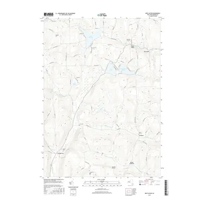
2016 Map of West Eaton
USGS Topo · Published 2016About this map
West Eaton and its neighboring hamlets sit within a landscape defined by the headwaters of the Otselic River and the regulated flows of the Eaton Reservoir. This 2016 survey shows the enduring footprint of small Madison County settlements like Lebanon and Georgetown, where family history is anchored by numerous burial grounds including Hawk Cem and Lebanon Valley Cem. The map illustrates a complex drainage system where Eaton Brook and Lebanon Brook carve through high ground, such as Dunhams Pinnacle and Jackass Hill. This modern study reveals how the historic water-management infrastructure, like the Bradley Brook Reservoir, continues to shape the local geography alongside newer residential roads near Hatch Lake.
Find a feature on this map
84 named features on this map. Tap any name to fly to it.
Don’t see what you’re looking for? This feature index may not catch every label — zoom into the map to look around manually.
Map Details
Editions of this 2016 West Eaton Map
This is the sole edition of this map. No revisions or reprints were ever made.
Other maps of this area

1897 · Cazenovia
USGS Topo · 1:62,500

1899 · Cazenovia
USGS Topo · 1:62,500

1902 · Morrisville
USGS Topo · 1:62,500

1903 · Norwich
USGS Topo · 1:62,500

1904 · Pitcher
USGS Topo · 1:62,500

1943 · Otselic
USGS Topo · 1:24,000
1943 · Cazenovia
USGS Topo · 1:24,000

1943 · West Eaton
USGS Topo · 1:24,000

1943 · Morrisville
USGS Topo · 1:24,000

1943 · South Ostelic
USGS Topo · 1:24,000