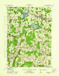
1944 Map of West Eaton
USGS Topo · Published 1944About this map
Madison County's central hills define the landscape of this mid-century survey, where the township boundaries of Nelson, Eaton, Georgetown, and Lebanon converge. The topography is shaped by a significant network of upland water bodies, including Eaton Reservoir and the Bradley Brook Reservoir, which dominate the northern half of the sheet. These reservoirs and smaller features like Hatch Lake and Torpy Pond indicate a landscape heavily managed for water resources.
Find a feature on this map
28 named features on this map. Tap any name to fly to it.
Don’t see what you’re looking for? This feature index may not catch every label — zoom into the map to look around manually.
Map Details
Editions of this 1944 West Eaton Map
This is the sole edition of this map. No revisions or reprints were ever made.
Other maps of this area

1897 · Cazenovia
USGS Topo · 1:62,500

1899 · Cazenovia
USGS Topo · 1:62,500

1902 · Morrisville
USGS Topo · 1:62,500

1903 · Norwich
USGS Topo · 1:62,500

1904 · Pitcher
USGS Topo · 1:62,500

1943 · Otselic
USGS Topo · 1:24,000
1943 · Cazenovia
USGS Topo · 1:24,000

1943 · West Eaton
USGS Topo · 1:24,000

1943 · Morrisville
USGS Topo · 1:24,000

1943 · South Ostelic
USGS Topo · 1:24,000