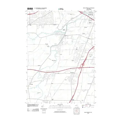
2010 Map of West Henrietta
USGS Topo · Published 2010About this map
The Genesee River serves as the central geographic corridor for this region south of Rochester, winding northward past the Ballantyne Bridge and the rail hub at Genesee Junction. The landscape reflects a mix of academic expansion, industrial presence, and early pioneer roots. To the north, the University of Rochester School of Medicine and Dentistry and University of Rochester South Campus anchor the suburban edge, while the southern reaches maintain a more rural character defined by traditional family landmarks. Local history is preserved in numerous burial grounds, including Bushman Cemetery, Martin Cemetery, and River View Cemetery. Significant terrain features like Methodist Hill and the Cedar Swamp southeast of West Henrietta illustrate the varied drainage patterns and elevations that shaped the development of settlements like Scottsville and Chili Center during the early 21st century.
Find a feature on this map
70 named features on this map. Tap any name to fly to it.
Don’t see what you’re looking for? This feature index may not catch every label — zoom into the map to look around manually.
Map Details
Editions of this 2010 West Henrietta Map
This is the sole edition of this map. No revisions or reprints were ever made.
Other maps of this area

1895 · Rochester
USGS Topo · 1:62,500

1898 · Rochester
USGS Topo · 1:62,500

1899 · Brockport
USGS Topo · 1:62,500

1901 · Honeoye
USGS Topo · 1:62,500

1904 · Caledonia
USGS Topo · 1:62,500

1904 · Honeoye
USGS Topo · 1:62,500

1912 · Rochester
USGS Topo · 1:62,500

1920 · Rochester
USGS Topo · 1:62,500

1931 · Mendon Ponds
USGS Topo · 1:24,000

1931 · Rochester West
USGS Topo · 1:24,000