
1972 Map of West Lincoln
USGS Topo · Published 1974About this map
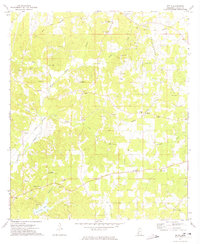
The East Fork Amite River winds through this rural portion of Lincoln County, defining a landscape of creek-fed hollows and scattered agricultural settlements in the early 1970s. The community of West Lincoln sits at a crossroads in the northern section, while Arlington and Center Point anchor the southern reaches of the map. This survey is particularly valuable for genealogists, as it identifies several denominational landmarks and family-associated burial grounds, including the Mt Zion Ch, Bethel Ch, and the Moak & Sasser Cem. Industrial and utility footprints are visible through several scattered Gravel Pit sites, an Oil Well, and a major Pipeline corridor. The presence of a small Landing Strip and the Montgomery Cem near the southern border reflect the diverse land use of this Mississippi countryside during the late twentieth century.
Find a feature on this map
20 named features on this map. Tap any name to fly to it.
Don’t see what you’re looking for? This feature index may not catch every label — zoom into the map to look around manually.
Map Details
Editions of this 1972 West Lincoln Map
This is the sole edition of this map. No revisions or reprints were ever made.
Other maps of this area

1953 · Natchez
USGS Topo · 1:250,000

1956 · Natchez
USGS Topo · 1:250,000

1959 · Natchez
USGS Topo · 1:250,000

1972 · Smithdale
USGS Topo · 1:24,000

1972 · McCall Creek
USGS Topo · 1:24,000

1972 · Little Springs
USGS Topo · 1:24,000

1972 · Auburn
USGS Topo · 1:24,000

1972 · Bogue Chitto
USGS Topo · 1:24,000

1972 · Brookhaven
USGS Topo · 1:24,000
1972 · Zetus
USGS Topo · 1:24,000