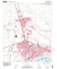
1997 Map of West Memphis
USGS Topo · Published 2001About this map
West Memphis and the neighboring city of Marion define this landscape just west of the Mississippi River in Crittenden County. This late 1990s record documents the significant urban and infrastructure development between the river and the inland bayous, including the extensive network of drainage features like the Tenmile Bayou Diversion Ditch. The map details a community deeply integrated with transportation and recreation, showing the West Memphis Airport and the Southland Park Racetrack as major local landmarks. Institutional foundations are well-represented by the Crittenden Memorial Hospital, Wonder High Sch, and several local churches like St Johns Ch. To the south, the map illustrates the complex river boundary at Vice Presidents Island No 46, where the Arkansas Tennessee state line follows an Indefinite Boundary through the shifting river course and reclaimed bottomlands.
Find a feature on this map
54 named features on this map. Tap any name to fly to it.
Don’t see what you’re looking for? This feature index may not catch every label — zoom into the map to look around manually.
Map Details
Editions of this 1997 West Memphis Map
This is the sole edition of this map. No revisions or reprints were ever made.
Other maps of this area

1916 · Memphis
USGS Topo · 1:62,500

1925 · Memphis
USGS Topo · 1:48,000

1927 · Memphis
USGS Topo · 1:62,500

1931 · Jericho
USGS Topo · 1:62,500

1939 · Jericho
USGS Topo · 1:62,500

1939 · Edmondson
USGS Topo · 1:62,500

1939 · Memphis
USGS Topo · 1:62,500

1940 · Deckerville
USGS Topo · 1:62,500

1952 · Jericho
USGS Topo · 1:62,500

1953 · Memphis
USGS Topo · 1:250,000