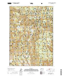
2020 Map of West Myrtle Butte
USGS Topo · Published 2020About this map
Malheur National Forest dominates this section of the Oregon high country, where the boundary between Grant Co and Harney Co bisects a landscape defined by volcanic buttes and a dense network of mountain springs. The terrain is anchored by West Myrtle Butte and Sugarloaf Mtn, with the surrounding slopes feeding numerous drainage systems including W Myrtle Cr and Bear Cr. Historically, these water sources have been vital for life in the arid uplands, as evidenced by the naming of nearly two dozen individual springs, such as Tipton Spring, Gribble Spring, and the uniquely named Wogonagat potso- na Flat Spring. Open clearings like Sallys Flat and Badger Flat break the forest cover, providing landmarks for navigation and land use in this high-elevation wilderness.
Find a feature on this map
40 named features on this map. Tap any name to fly to it.
Don’t see what you’re looking for? This feature index may not catch every label — zoom into the map to look around manually.
Map Details
Editions of this 2020 West Myrtle Butte Map
This is the sole edition of this map. No revisions or reprints were ever made.
Other maps of this area

1955 · Burns
USGS Topo · 1:250,000

1955 · Canyon City
USGS Topo · 1:250,000

1958 · Burns
USGS Topo · 1:250,000

1959 · Burns
USGS Topo · 1:250,000

1959 · Canyon City
USGS Topo · 1:250,000

1959 · West Myrtle Butte
USGS Topo · 1:62,500

1959 · Sawtooth Creek
USGS Topo · 1:62,500

1961 · Logdell
USGS Topo · 1:62,500

1961 · Izee
USGS Topo · 1:62,500

1981 · Dayville
USGS Topo · 1:100,000