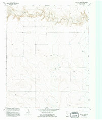
1964 Map of West of Brickel
USGS Topo · Published 1995About this map
Coldwater Creek carves a deep, winding path across the northern reaches of the High Plains in Dallam County, defining the primary relief in this otherwise high-altitude plateau. The landscape recorded in this 1964 survey, produced in cooperation with the Texas Water Development Board, is one of sparse habitation and critical water management. The survey documents the infrastructure of ranching and early resource exploration across the Panhandle, noting various Wells and specific industrial markers like the 3859 Drill Hole. Settlement is minimal, with landmarks such as the Cistern 3907 and Well 3886 serving as vital points of reference in a region defined by its wide, open drainages like Cow Draw. This map provides a clear view of the land division and water-sourcing efforts essential for survival in this arid Texas corner.
Find a feature on this map
12 named features on this map. Tap any name to fly to it.
Don’t see what you’re looking for? This feature index may not catch every label — zoom into the map to look around manually.
Map Details
Editions of this 1964 West of Brickel Map
2 editions found
Other maps of this area

1954 · Dalhart
USGS Topo · 1:250,000

1958 · Dalhart
USGS Topo · 1:250,000

1962 · Dalhart
USGS Topo · 1:250,000

1964 · Brickel
USGS Topo · 1:24,000

1964 · Kerrick
USGS Topo · 1:24,000

1964 · Stratford 2 SE
USGS Topo · 1:24,000

1964 · Stratford 2 NE
USGS Topo · 1:24,000

1965 · Conlen
USGS Topo · 1:24,000

1965 · Wilco NE
USGS Topo · 1:24,000

1973 · Stratford 2 NW
USGS Topo · 1:24,000