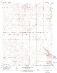
1974 Map of West of Eminence Cemetery
USGS Topo · Published 1993About this map
Pleasant Valley defines the topography of this western Kansas landscape, where the wide plains of Garfield meet a complex network of resource extraction. Surveyed in the mid-1970s, the map reveals a shift from traditional prairie land-use toward an intensive focus on subsurface wealth. The terrain is marked by numerous industrial sites, including several Well and Gas Well locations, alongside a specific Drill Hole and a Gravel Pit near the eastern boundary. Hydrology is sparse but significant, notably highlighted by the presence of Springs in the southeastern quadrant. This survey provides a clear look at the intersection of rural land management and energy development in Finney County during an era of expanding domestic production.
Find a feature on this map
10 named features on this map. Tap any name to fly to it.
Don’t see what you’re looking for? This feature index may not catch every label — zoom into the map to look around manually.
Map Details
Editions of this 1974 West of Eminence Cemetery Map
2 editions found
Other maps of this area

1940 · Scott City
USGS Topo · 1:62,500

1944 · Tennis
USGS Topo · 1:62,500

1951 · Scott City
USGS Topo · 1:62,500

1955 · Scott City
USGS Topo · 1:250,000

1958 · Scott City
USGS Topo · 1:250,000
1974 · Scott City 4 SW
USGS Topo · 1:24,000
1974 · Scott City 4 SE
USGS Topo · 1:24,000
1974 · Scott City 4 NW
USGS Topo · 1:24,000

1974 · Amy SE
USGS Topo · 1:24,000

1974 · Scott City 4 NE
USGS Topo · 1:24,000