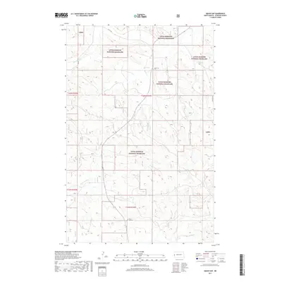
2017 Map of West of Flat Rock Butte
USGS Topo · Published 2017About this map
The Little Missouri National Grassland dominates this section of McKenzie County, revealing a landscape defined by its drainages and early twentieth-century land divisions. The terrain is dissected by seasonal waterways including One-O-One Cr, Spring Cr, and the descriptively named Poison Spring Cr. These creek beds and coulees dictated the placement of early infrastructure, such as 101 Rd and 15th St NW, which follow the section lines of the Public Land Survey System. For those tracing the history of the area's homesteaders, two critical local landmarks are preserved here: Squaw Gap Cem and Sunny Side Cem. These small burial grounds serve as the primary records of the families who settled this high plains country. The presence of Flat Rock St on the eastern edge provides a natural landmark amidst the repeating grid of North Dakota's rangeland.
Find a feature on this map
15 named features on this map. Tap any name to fly to it.
Don’t see what you’re looking for? This feature index may not catch every label — zoom into the map to look around manually.
Map Details
Editions of this 2017 West of Flat Rock Butte Map
This is the sole edition of this map. No revisions or reprints were ever made.
Other maps of this area

1909 · Glendive
USGS Topo · 1:250,000

1953 · Watford City
USGS Topo · 1:250,000

1954 · Glendive
USGS Topo · 1:250,000

1957 · Glendive
USGS Topo · 1:250,000

1957 · Watford City
USGS Topo · 1:250,000

1958 · Glendive
USGS Topo · 1:250,000

1967 · Watford City
USGS Topo · 1:250,000

1972 · Sidney SE
USGS Topo · 1:24,000
1972 · Phillip Spring
USGS Topo · 1:24,000

1972 · Sheep Creek
USGS Topo · 1:24,000