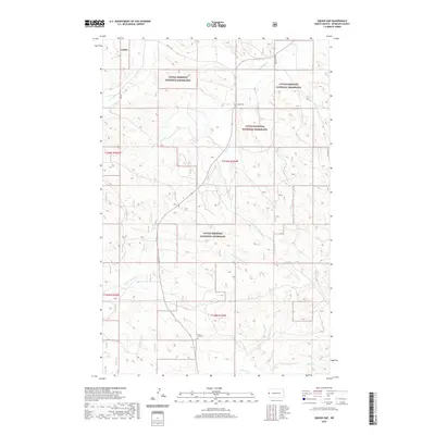
2020 Map of West of Flat Rock Butte
USGS Topo · Published 2020About this map
Little Missouri National Grassland dominates this section of McKenzie County, where the topography is defined by the drainage basins of Spring Cr and Poison Spring Cr. The map reveals a sparsely populated ranching or farming landscape where local landmarks like Squaw Gap Cem and Sunny Side Cem provide important genealogical touchstones for families of the western Dakota plains. A network of rural routes, including Flat Rock Rd and 15th St NW, connects the section lines and provides access across the various townships. This modern survey reflects the enduring character of the Badlands region, showing how the drainage of One-O-One Cr and O'Neil Cr shapes the movement and settlement patterns across the grassland today.
Find a feature on this map
15 named features on this map. Tap any name to fly to it.
Don’t see what you’re looking for? This feature index may not catch every label — zoom into the map to look around manually.
Map Details
Editions of this 2020 West of Flat Rock Butte Map
This is the sole edition of this map. No revisions or reprints were ever made.
Other maps of this area

1909 · Glendive
USGS Topo · 1:250,000

1953 · Watford City
USGS Topo · 1:250,000

1954 · Glendive
USGS Topo · 1:250,000

1957 · Glendive
USGS Topo · 1:250,000

1957 · Watford City
USGS Topo · 1:250,000

1958 · Glendive
USGS Topo · 1:250,000

1967 · Watford City
USGS Topo · 1:250,000

1972 · Sidney SE
USGS Topo · 1:24,000
1972 · Phillip Spring
USGS Topo · 1:24,000

1972 · Sheep Creek
USGS Topo · 1:24,000