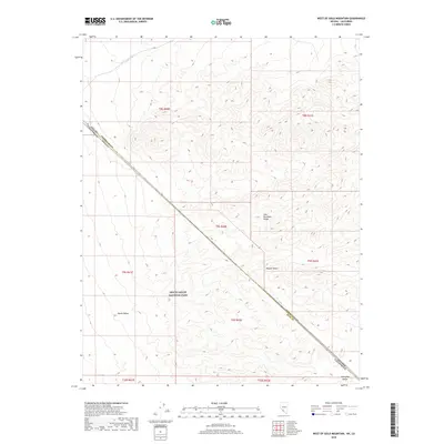
2018 Map of West of Gold Mountain
USGS Topo · Published 2018About this map
The Gold Mountain Range and the Amargosa Range converge in this high-elevation corner of the eastern California desert. This 2018 survey documents a remote landscape dominated by the protected expanses of Death Valley National Park. The terrain shifts from the northern reaches of the Mojave Desert into the iconic sink of Death Valley itself, with the diagonal boundary between Nevada and California cutting through the topographic relief. To the north, the drainage of Oriental Wash provides a rare point of named hydrology in an otherwise arid region defined by sharp ridgelines and vast alluvial slopes. The map traces the jurisdictional intersection of Esmeralda and Inyo Counties, illustrating how state and county lines were historically surveyed across this formidable mountain environment.
Find a feature on this map
15 named features on this map. Tap any name to fly to it.
Don’t see what you’re looking for? This feature index may not catch every label — zoom into the map to look around manually.
Map Details
Editions of this 2018 West of Gold Mountain Map
This is the sole edition of this map. No revisions or reprints were ever made.
Other maps of this area

1908 · Lida
USGS Topo · 1:250,000

1913 · Lida
USGS Topo · 1:250,000

1954 · Goldfield
USGS Topo · 1:250,000

1955 · Goldfield
USGS Topo · 1:250,000

1957 · Magruder Mtn
USGS Topo · 1:62,500

1957 · Ubehebe Crater
USGS Topo · 1:62,500

1958 · Goldfield
USGS Topo · 1:250,000

1958 · Last Chance Range
USGS Topo · 1:62,500

1962 · Goldfield
USGS Topo · 1:250,000
1968 · Gold Point SW
USGS Topo · 1:24,000