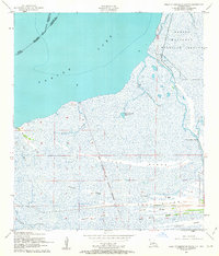
1957 Map of West of Johnson Bayou
USGS Topo · Published 1962About this map
Sabine Lake defines the western edge of this coastal landscape, where the marshlands of Cameron Parish meet the Texas border. The terrain is characterized by a series of long, narrow elevations known locally as ridges, which provided the only stable ground for travel and settlement in this delta environment. Notable examples include Garrison Ridge, Buck Ridge, and Blue Buck Ridge, which run parallel to the Gulf coast. These ridges often carry the names of early families and historical industries, such as Salt Work Ridge and Garner Ridge. Waterways like Stark's Canal and Gray's Canal cut through the wetlands, supporting drainage and navigation. Along the eastern edge, Johnsons Bayou Landing serves as a key access point to Deep Johnsons Bayou, while the Sabine National Wildlife Refuge preserves the primitive character of the shoreline. An Old Military Reservation East Boundary remains marked on the landscape, providing a trace of federal history in this remote bayou country.
Find a feature on this map
28 named features on this map. Tap any name to fly to it.
Don’t see what you’re looking for? This feature index may not catch every label — zoom into the map to look around manually.
Map Details
Editions of this 1957 West of Johnson Bayou Map
3 editions found
Other maps of this area

1932 · Sabine Pass NE
USGS Topo · 1:31,680

1932 · Port Arthur NE
USGS Topo · 1:31,680

1934 · Johnsons Bayou
USGS Topo · 1:24,000

1934 · Greens Bayou
USGS Topo · 1:24,000

1935 · Greens Bayou
USGS Topo · 1:31,680

1935 · Johnsons Bayou
USGS Topo · 1:31,680

1943 · West of Johnson Bayou
USGS Topo · 1:24,000

1943 · West of Greens Bayou
USGS Topo · 1:24,000

1943 · Port Arthur North
USGS Topo · 1:24,000

1943 · Port Arthur South
USGS Topo · 1:24,000