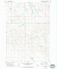
1972 Map of West Of Stony Butte
USGS Topo · Published 1994About this map
East Branch War Creek flows through the northern reaches of this rural landscape in Jones County, defining a drainage pattern that breaks the open prairie. The terrain is organized into distinct namesake regions, including Richland and War Creek in the north, and Virgil and Rich Valley to the south. This 1970s topographic survey captures the area before modern changes, illustrating a high-plains environment defined primarily by its hydrology and section-line boundaries. Local history researchers can observe how the watercourses, particularly the tributaries of the creek, dictate the local topography and have historically influenced land division in this part of South Dakota.
Find a feature on this map
7 named features on this map. Tap any name to fly to it.
Don’t see what you’re looking for? This feature index may not catch every label — zoom into the map to look around manually.
Map Details
Editions of this 1972 West Of Stony Butte Map
2 editions found
Other maps of this area

1953 · Wendte NE
USGS Topo · 1:24,000

1953 · Pierre 3 NW
USGS Topo · 1:24,000

1954 · Pierre
USGS Topo · 1:250,000

1955 · Martin
USGS Topo · 1:250,000

1958 · Pierre
USGS Topo · 1:250,000

1958 · Martin
USGS Topo · 1:250,000

1972 · Pierre 3 SW
USGS Topo · 1:24,000

1972 · Draper
USGS Topo · 1:24,000

1972 · Pierre 3 SE
USGS Topo · 1:24,000

1972 · Vivian
USGS Topo · 1:24,000