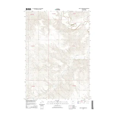
2015 Map of West of Westover
USGS Topo · Published 2015About this map
The White River winds through the northern portion of this South Dakota landscape, defining the county line between Jones Co and Mellette Co. This 2015 survey reveals a terrain deeply etched by seasonal drainage patterns, most notably the winding paths of Butch Cr and Cottonwood Cr. The road network is primarily composed of numbered avenues and streets alongside several routes bearing descriptive or local names, such as Swift Horse Rd and Charging Elk Rd. These roads often follow the high ridges between creek valleys, particularly Valley View Rd and Ridgeway Rd. The map illustrates a rural western setting where the natural topography dictates the movement of people and the placement of infrastructure, with the large meanders of the White River serving as the dominant geographic landmark in the territory.
Find a feature on this map
25 named features on this map. Tap any name to fly to it.
Don’t see what you’re looking for? This feature index may not catch every label — zoom into the map to look around manually.
Map Details
Editions of this 2015 West of Westover Map
This is the sole edition of this map. No revisions or reprints were ever made.
Other maps of this area

1951 · Okaton SW
USGS Topo · 1:24,000

1951 · Westover
USGS Topo · 1:24,000

1951 · Murdo SW
USGS Topo · 1:24,000

1951 · Murdo 3 NW
USGS Topo · 1:24,000

1951 · Murdo 3 NE
USGS Topo · 1:24,000

1951 · Okaton SE
USGS Topo · 1:24,000

1955 · Martin
USGS Topo · 1:250,000

1958 · Martin
USGS Topo · 1:250,000
1982 · Murdo 3 NW
USGS Topo · 1:25,000

1982 · White River East
USGS Topo · 1:24,000