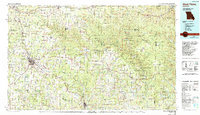
1984 Map of West Plains
USGS Topo · Published 1990About this map
The Ozark plateau in southern Missouri is anchored here by West Plains, showing a landscape defined by its deep river systems and extensive woodland reserves. The Burlington Northern RR cuts a path through the region, connecting hubs like Willow Springs, Pomona, and Koshkonong to the larger rail network. This era shows the dominance of the Mark Twain National Forest, which blankets the eastern hills where the Eleven Point River and Current River carve through the terrain. Cultural landmarks such as White Church and the Howell Cem provide touchpoints for local genealogy, while the presence of Siloam Springs and Grand Gulf State Park highlights the unique geological features of the area. Large tracts like the Peck Ranch State Wildlife Area and Dean Davis State Wildlife Area demonstrate the focus on conservation and forest management during the mid-1980s.
Find a feature on this map
95 named features on this map. Tap any name to fly to it.
Don’t see what you’re looking for? This feature index may not catch every label — zoom into the map to look around manually.
Map Details
Editions of this 1984 West Plains Map
2 editions found
Other maps of this area

1890 · Mountain Home
USGS Topo · 1:125,000

1891 · Mountain Home
USGS Topo · 1:125,000

1894 · Mountain Home
USGS Topo · 1:125,000

1915 · Eminence
USGS Topo · 1:62,500

1917 · Eminence
USGS Topo · 1:62,500

1928 · Cardareva
USGS Topo · 1:62,500

1931 · Bandyville
USGS Topo · 1:48,000

1935 · Reyno
USGS Topo · 1:62,500

1938 · West Plains
USGS Topo · 1:24,000

1939 · Topaz
USGS Topo · 1:62,500