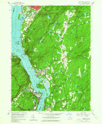
1941 Map of West Point
USGS Topo · Published 1951About this map
The U S Military Academy West Point and its surrounding river terrain dominate this mid-century survey of the Highlands. The map illustrates a dense concentration of religious and educational institutions, including St Lawrence Seminary, St Josephs Novitiate, and St Basils Academy. Along the Hudson River, the New York Central Railroad tracks follow the eastern shoreline through Cold Spring and past Constitution Island, while the Central New York Railroad serves the western bank. Notable infrastructure includes the Catskill Aqueduct crossing and the highly secure U S Silver Depository. This era shows the developed campuses and athletic grounds like Michie Stadium alongside the established river towns of Beacon and Highland Falls, which were shaped by their proximity to the military academy and the primary rail corridors connecting New York City to Albany.
Find a feature on this map
98 named features on this map. Tap any name to fly to it.
Don’t see what you’re looking for? This feature index may not catch every label — zoom into the map to look around manually.
Map Details
Editions of this 1941 West Point Map
This is the sole edition of this map. No revisions or reprints were ever made.
Other maps of this area

1892 · West Point
USGS Topo · 1:62,500

1893 · Poughkeepsie
USGS Topo · 1:62,500

1894 · West Point
USGS Topo · 1:62,500

1894 · Poughkeepsie
USGS Topo · 1:62,500

1899 · West Point
USGS Topo · 1:62,500

1901 · West Point
USGS Topo · 1:62,500

1902 · Schunemunk
USGS Topo · 1:62,500

1903 · Poughkeepsie
USGS Topo · 1:62,500

1903 · Newburg
USGS Topo · 1:62,500

1930 · Schunemunk
USGS Topo · 1:48,000