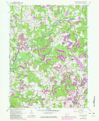
1963 Map of West Sunbury
USGS Topo · Published 1980About this map
West Sunbury serves as a focal point for this Butler County landscape, which by the early 1960s was defined by a complex intersection of heavy industry and natural conservation. The Bessemer and Lake Erie railroad cuts through the terrain, connecting small settlements like Branchton, Boyers, and Annandale. These rail corridors highlight the region's industrial heritage, evidenced by a Strip Mine and multiple pipelines that traverse the township boundaries of Cherry, Marion, and Clay.
Find a feature on this map
50 named features on this map. Tap any name to fly to it.
Don’t see what you’re looking for? This feature index may not catch every label — zoom into the map to look around manually.
Map Details
Editions of this 1963 West Sunbury Map
3 editions found
Other maps of this area

1908 · Zelienople
USGS Topo · 1:62,500

1909 · Butler
USGS Topo · 1:62,500

1910 · Zelienople
USGS Topo · 1:62,500

1910 · Hilliards
USGS Topo · 1:62,500

1911 · Butler
USGS Topo · 1:62,500

1912 · Hilliards
USGS Topo · 1:62,500

1913 · Mercer
USGS Topo · 1:62,500

1939 · Mercer
USGS Topo · 1:62,500

1943 · Mercer
USGS Topo · 1:62,500

1944 · Hilliards
USGS Topo · 1:62,500