
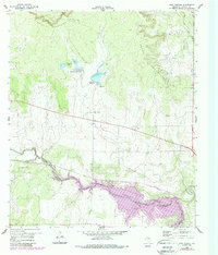
1960 Map of West Sweden
USGS Topo · Published 1961About this map
West Sweden stands as a focal point in this Central Texas landscape, where the agricultural plains meet the rising slopes of the Brady Mountains. Surveyed in the early 1960s, the map reveals a countryside defined by water management and transit, featuring Reservoir No 43 A and Reservoir No 43 B alongside the winding course of Brady Creek. The presence of the Carroll Colony Cem provides a specific point of interest for genealogists tracing family roots in this corner of McCulloch County.
Find a feature on this map
15 named features on this map. Tap any name to fly to it.
Don’t see what you’re looking for? This feature index may not catch every label — zoom into the map to look around manually.
Map Details
Editions of this 1960 West Sweden Map
2 editions found
Other maps of this area

1892 · Eden
USGS Topo · 1:125,000

1894 · Brady
USGS Topo · 1:125,000

1896 · Eden
USGS Topo · 1:125,000

1928 · Waldrip
USGS Topo · 1:62,500

1931 · Stacy
USGS Topo · 1:62,500

1954 · Brownwood
USGS Topo · 1:250,000

1960 · Melvin
USGS Topo · 1:24,000

1960 · Brady North
USGS Topo · 1:24,000

1963 · Brady SW
USGS Topo · 1:24,000
1967 · Salt Gap
USGS Topo · 1:24,000