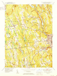
1951 Map of West Torrington
USGS Topo · Published 1951About this map
John Browns Birthplace (Ruins) stands as a poignant historical marker in the hills of Torrington, documenting the early heritage of this Litchfield County landscape. The mid-century environment is characterized by a high concentration of educational and social institutions, including the Junior Republic of Connecticut, The Forman School, and the St Louis De Montfort Seminary. Residential growth is visible at Newberry Corner and Wrightville, while the industrial legacy of the region is traced along the Naugatuck River and its various tributaries like Hall Meadow Brook.
Find a feature on this map
76 named features on this map. Tap any name to fly to it.
Don’t see what you’re looking for? This feature index may not catch every label — zoom into the map to look around manually.
Map Details
Editions of this 1951 West Torrington Map
2 editions found
Other maps of this area

1892 · Winsted
USGS Topo · 1:62,500

1892 · Cornwall
USGS Topo · 1:62,500

1892 · New Milford
USGS Topo · 1:62,500

1893 · Waterbury
USGS Topo · 1:62,500

1893 · New Milford
USGS Topo · 1:62,500

1893 · Cornwall
USGS Topo · 1:62,500

1903 · Cornwall
USGS Topo · 1:62,500

1904 · New Milford
USGS Topo · 1:62,500

1904 · Waterbury
USGS Topo · 1:62,500

1904 · Litchfield
USGS Topo · 1:125,000