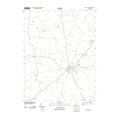
2010 Map of West Union
USGS Topo · Published 2010About this map
West Union serves as the central hub of this Adams County landscape, where the local road network converges near the West Union Post Office. The surrounding terrain is defined by a series of prominent rises including Coon Hill, Spencer Hill, and Cave Hill, with numerous drainage systems like East Fork Eagle Creek and Beasley Fork carving through the countryside. This 2010 survey highlights a significant number of family and fraternal burial grounds, ranging from the Independent Order of Oddfellows Cemetery north of town to the more secluded Nixon Cemetery and Hale Cemetery to the south. Transportation and infrastructure are represented by the Alexander Salamon Airport and several water management features such as Dodge Pond Dam and Adams Lake Dam. Local history is anchored by landmarks like the Kirker Bridge over Hills Fork, providing a detailed view of the rural settlement patterns in southern Ohio at the start of the 21st century.
Find a feature on this map
71 named features on this map. Tap any name to fly to it.
Don’t see what you’re looking for? This feature index may not catch every label — zoom into the map to look around manually.
Map Details
Editions of this 2010 West Union Map
This is the sole edition of this map. No revisions or reprints were ever made.
Other maps of this area

1916 · Peebles
USGS Topo · 1:62,500

1918 · Peebles
USGS Topo · 1:62,500

1918 · Seaman
USGS Topo · 1:62,500

1919 · Vanceburg
USGS Topo · 1:62,500

1929 · Springdale
USGS Topo · 1:48,000

1935 · Springdale
USGS Topo · 1:62,500

1949 · Vanceburg
USGS Topo · 1:62,500

1949 · Concord
USGS Topo · 1:24,000
1951 · Concord
USGS Topo · 1:24,000

1952 · Maysville East
USGS Topo · 1:24,000