1961 Map of West Union
USGS Topo · Published 1977About this map
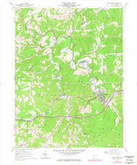
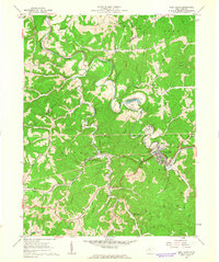
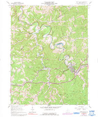
West Union serves as the focal point of this survey, where the Baltimore And Ohio railroad tracks follow the winding course of the Middle Island Creek. The landscape is defined by the deep valleys and ridges of Doddridge County, where numerous small runs and forks converge. The settlement pattern reveals a series of rural nodes such as Central Station and Duckworth, which are connected by the rail line and established road networks. For those tracing family histories, the map identifies several local landmarks including the Masonic Cem and the Fleming Cem Arnold Creek Ch. The presence of Strip Mines and numerous gas wells across the hillsides points to the extraction-based economy that shaped the region during this period. The survey also highlights local water features like Crystal Lake and Arnold Creek, illustrating how the community utilized the narrow bottomlands between the ridges for both industry and settlement.
Find a feature on this map
51 named features on this map. Tap any name to fly to it.
Don’t see what you’re looking for? This feature index may not catch every label — zoom into the map to look around manually.
Map Details
Editions of this 1961 West Union Map
3 editions found
Other maps of this area

1904 · Vadis
USGS Topo · 1:62,500

1905 · Centerpoint
USGS Topo · 1:62,500

1905 · West Union
USGS Topo · 1:62,500

1906 · Holbrook
USGS Topo · 1:62,500

1924 · Centerpoint
USGS Topo · 1:62,500

1924 · West Union
USGS Topo · 1:62,500

1924 · Holbrook
USGS Topo · 1:62,500

1925 · Centerpoint
USGS Topo · 1:62,500

1925 · Vadis
USGS Topo · 1:62,500

1926 · Holbrook
USGS Topo · 1:62,500