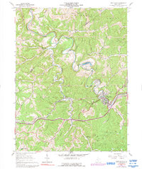
1961 Map of West Union
USGS Topo · Published 1992About this map
The town of West Union serves as a focal point in this portion of Doddridge County, where the Baltimore and Ohio railroad corridor dictates the path of commerce and transit along the valley. The landscape is characterized by a dense network of winding waterways, including Middle Island Creek and its many tributaries such as Arnold Creek and Rock Run. Higher elevations are defined by prominent ridges like Haymond Ridge and Duckworth Ridge, which separate the various hollows and smaller settlements.
Find a feature on this map
51 named features on this map. Tap any name to fly to it.
Don’t see what you’re looking for? This feature index may not catch every label — zoom into the map to look around manually.
Map Details
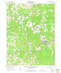
Editions of this 1961 West Union Map
3 editions found
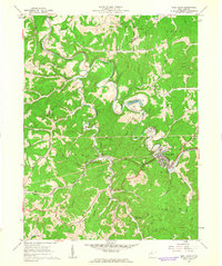
Other maps of this area

1904 · Vadis
USGS Topo · 1:62,500

1905 · Centerpoint
USGS Topo · 1:62,500

1905 · West Union
USGS Topo · 1:62,500

1906 · Holbrook
USGS Topo · 1:62,500

1924 · Centerpoint
USGS Topo · 1:62,500

1924 · West Union
USGS Topo · 1:62,500

1924 · Holbrook
USGS Topo · 1:62,500

1925 · Centerpoint
USGS Topo · 1:62,500

1925 · Vadis
USGS Topo · 1:62,500

1926 · Holbrook
USGS Topo · 1:62,500