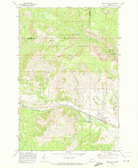
1971 Map of West Valley
USGS Topo · Published 1973About this map
The Butte Anaconda and Pacific railroad cuts a straight path through the southern half of this Montana landscape, tracing the valley of Warm Springs Creek. The industrial character of the region is evident in the numerous Mines and Prospects scattered across the northern slopes of Garrity Mountain and the southern reaches of the Deerlodge National Forest. While small settlements like West Valley and Stump Town concentrate near the rail line, the map also captures mid-century recreation and infrastructure, from the Lost Creek State Park in the northeast to the Drive-in Theater and Hatcher Field on the valley floor. Steep gulches like Blue Eyed Nellie Gulch and Priebe Gulch drain the high country, where logging and mining roads navigate the terrain between Olsen Mountain and Stucky Ridge.
Find a feature on this map
37 named features on this map. Tap any name to fly to it.
Don’t see what you’re looking for? This feature index may not catch every label — zoom into the map to look around manually.
Map Details
Editions of this 1971 West Valley Map
2 editions found
Other maps of this area

1889 · Helena
USGS Topo · 1:250,000

1893 · Helena
USGS Topo · 1:250,000

1899 · Helena
USGS Topo · 1:250,000

1903 · Helena
USGS Topo · 1:250,000

1908 · Philipsburg
USGS Topo · 1:125,000

1947 · Butte
USGS Topo · 1:250,000

1958 · Butte
USGS Topo · 1:250,000

1960 · Butte
USGS Topo · 1:250,000

1961 · Anaconda
USGS Topo · 1:62,500

1962 · Butte
USGS Topo · 1:250,000