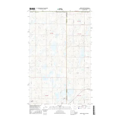
2017 Map of Westby North
USGS Topo · Published 2017About this map
The state boundary between Montana and North Dakota bisects this prairie landscape, where the town of Westby sits at the intersection of international and interstate lines. Just south of the Canadian border, the topography is defined by a dense concentration of glacial potholes and small water bodies, including Mc Cone Lake, Gaulke Lake, and North Lake. These wetlands dot the section lines of the Public Land Survey System, which organizes the region into townships such as t37n r58e and 164n 103w. Near the small settlement of McElroy, the Westby Catholic Cemetery serves as a significant genealogical landmark for the local community. The map illustrates a remote agricultural area where movement is dictated by a rigid grid of gravel roads like North Westby Road and 151st Avenue NW, connecting isolated farmsteads across the High Plains.
Find a feature on this map
31 named features on this map. Tap any name to fly to it.
Don’t see what you’re looking for? This feature index may not catch every label — zoom into the map to look around manually.
Map Details
Editions of this 2017 Westby North Map
This is the sole edition of this map. No revisions or reprints were ever made.
Other maps of this area

1953 · Williston
USGS Topo · 1:250,000

1954 · Wolf Point
USGS Topo · 1:250,000

1957 · Williston
USGS Topo · 1:250,000

1958 · Wolf Point
USGS Topo · 1:250,000

1983 · Tadpole Lake
USGS Topo · 1:24,000

1983 · Lone Tree Lake
USGS Topo · 1:24,000

1983 · Westby South
USGS Topo · 1:24,000

1983 · Alkabo
USGS Topo · 1:24,000

1983 · Westby North
USGS Topo · 1:24,000
1983 · Skjermo Lake
USGS Topo · 1:24,000