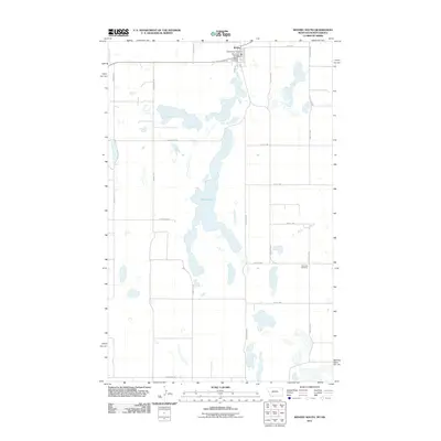
2011 Map of Westby South
USGS Topo · Published 2011About this map
Westby anchors the northern edge of this Sheridan County landscape, where the town's social and civic infrastructure is concentrated at the border of Montana and North Dakota. This survey documents a critical point of regional connectivity, with Stateline Rd and County Hwy-3 dividing the prairie into a rigid section grid. The terrain is defined by a north-south chain of prairie potholes, the largest being Goose Lake, which dominate the central drainage pattern. These water bodies dictate the winding paths of rural routes like Goose Lake Rd and Sand Flat Rd, contrasting with the surrounding linear agricultural roads. For researchers, the presence of the Westby Cemetery and the more remote Daneville Cemetery provides essential locations for tracing early families in this borderland community. The layout illustrates a classic High Plains settlement pattern where the Westby Post Office and Westby Vol Fire Dept remain the primary hubs for a widely dispersed farming population.
Find a feature on this map
26 named features on this map. Tap any name to fly to it.
Don’t see what you’re looking for? This feature index may not catch every label — zoom into the map to look around manually.
Map Details
Editions of this 2011 Westby South Map
This is the sole edition of this map. No revisions or reprints were ever made.
Other maps of this area

1953 · Williston
USGS Topo · 1:250,000

1954 · Wolf Point
USGS Topo · 1:250,000

1957 · Williston
USGS Topo · 1:250,000

1958 · Wolf Point
USGS Topo · 1:250,000

1983 · Tadpole Lake
USGS Topo · 1:24,000

1983 · Lone Tree Lake
USGS Topo · 1:24,000
1983 · Coalridge
USGS Topo · 1:24,000

1983 · Westby South
USGS Topo · 1:24,000

1983 · Alkabo
USGS Topo · 1:24,000

1983 · Westby North
USGS Topo · 1:24,000