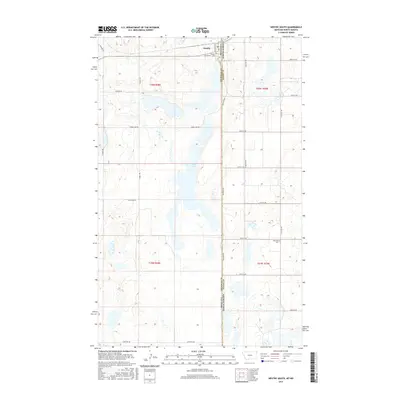
2017 Map of Westby South
USGS Topo · Published 2017About this map
Westby anchors the northern edge of this high-plains landscape where the borders of Montana and North Dakota meet. The map reveals a terrain defined by hundreds of small prairie potholes and seasonal wetlands, with Goose Lake serving as a central geographical landmark. This rural topography is organized by a precise grid of gravel roads including Stateline Rd and Jefferson Rd, reflecting the expansive township and range surveying system that shaped settlement in the MonDak region. Local history and genealogy are preserved in the two primary burial grounds shown, Westby Cem near the town center and Daneville Cem situated further south near the state boundary. The density of section-line roads like Scandia Rd and Lindell RD illustrates the persistence of the small-plot agricultural framework even as regional ranching and farming evolved into the 21st century.
Find a feature on this map
30 named features on this map. Tap any name to fly to it.
Don’t see what you’re looking for? This feature index may not catch every label — zoom into the map to look around manually.
Map Details
Editions of this 2017 Westby South Map
This is the sole edition of this map. No revisions or reprints were ever made.
Other maps of this area

1953 · Williston
USGS Topo · 1:250,000

1954 · Wolf Point
USGS Topo · 1:250,000

1957 · Williston
USGS Topo · 1:250,000

1958 · Wolf Point
USGS Topo · 1:250,000

1983 · Tadpole Lake
USGS Topo · 1:24,000

1983 · Lone Tree Lake
USGS Topo · 1:24,000
1983 · Coalridge
USGS Topo · 1:24,000

1983 · Westby South
USGS Topo · 1:24,000

1983 · Alkabo
USGS Topo · 1:24,000

1983 · Westby North
USGS Topo · 1:24,000