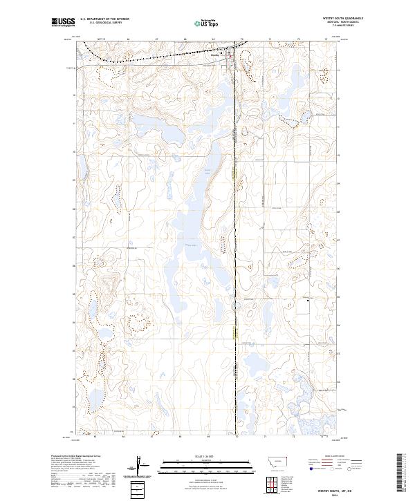
2024 Map of Westby South
USGS Topo · Published 2024About this map
Westby sits at the northern edge of this high plains landscape, where the border between Montana and North Dakota is defined by Stateline Rd. This agricultural and conservation-focused region is characterized by extensive wetland complexes, most notably the Sheridan County Waterfowl Production Area and the Divide County Waterfowl Production Area, which protect the vital prairie pothole habitat surrounding Goose Lake. Local history is anchored by the Westby Cem near the town site and the Daneville Cem situated to the southeast across the state line. A grid of rural routes such as McElroy Rd, Scandia Rd, and Lindell Rd provides access to the scattered farmsteads and township sections that define the modern land use in Sheridan and Divide Counties.
Find a feature on this map
34 named features on this map. Tap any name to fly to it.
Don’t see what you’re looking for? This feature index may not catch every label — zoom into the map to look around manually.
Map Details
Editions of this 2024 Westby South Map
This is the sole edition of this map. No revisions or reprints were ever made.
Other maps of this area

1953 · Williston
USGS Topo · 1:250,000

1954 · Wolf Point
USGS Topo · 1:250,000

1957 · Williston
USGS Topo · 1:250,000

1958 · Wolf Point
USGS Topo · 1:250,000

1983 · Tadpole Lake
USGS Topo · 1:24,000

1983 · Lone Tree Lake
USGS Topo · 1:24,000
1983 · Coalridge
USGS Topo · 1:24,000

1983 · Westby South
USGS Topo · 1:24,000

1983 · Alkabo
USGS Topo · 1:24,000

1983 · Westby North
USGS Topo · 1:24,000